The Local Story
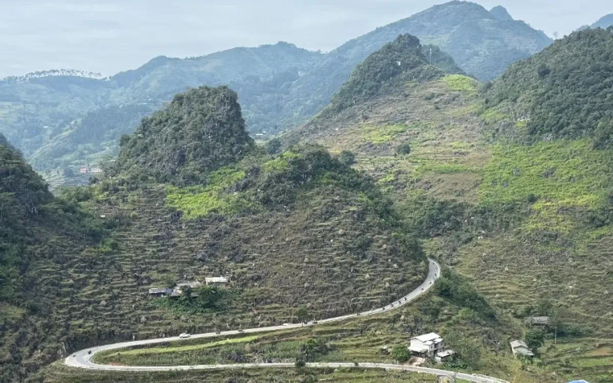
Carved into the limestone mountains of Sung Mang along the road between Yen Minh and Meo Vac, this remarkable pass folds back upon itself twice to create a giant, flowing 'M' against the hills. An elevated roadside gravel turnout at the crest offers the classic aerial perspective of motorcycles gliding through the bends. Park completely clear of the travel lane, watch for oncoming freight vans, and stop by around mid-morning when sunlight clears valley shadows.
In this guide
Winding through the rugged mountain terrain between Yen Minh and the Meo Vac region, the M-shaped pass in Sung Mang commune is one of the most photographed stretches of road on the Ha Giang Loop. Viewed from high pull-outs along the highway, the asphalt gracefully folds back upon itself twice in a clean, undulating 'M', forming an iconic symbol of human determination etched into living stone.
A geometric triumph across the karst
Constructed as part of the regional road network modernising historic pack-horse routes, the M-shaped curve was engineered to conquer an otherwise impassable vertical gradient:
- Engineering harmony: Rather than dynamiting a destructive scar directly through the mountain, road builders laid gentle switchbacks that flow naturally along the contours of the limestone ridges, minimizing rockfall risks.
- Aerial perspective: From the elevated viewing layby at the crest, motorbikes and minivans resemble tiny colourful dots carving smooth arcs through the sprawling gray expanse.
- Living terrace backdrop: The sweeping bends wrap around rustic terraced corn patches and stone-walled homesteads cultivated by local Hmong families.
Four seasons across Sung Mang valley
The visual character of the pass evolves with highland agriculture:
- Spring (January to March): Early morning mists drift across the curves like floating silk ribbons. The road appears and disappears through shifting cloud banks, while pink wild peach blossoms bloom beside rustic wooden homesteads.
- Summer (April to June): Brilliant emerald corn covers every pocket of arable soil inside the loops of the M. The contrast between bright green crops and dark gray karst limestone under bright summer sunshine is vivid.
- Autumn (July to September): The surrounding corn turns golden and is harvested in late summer. Clear blue skies and warm afternoon light create crisp, rhythmic shadows that accentuate every contour of the pavement.
- Winter (October to December): Roadside buckwheat flower patches bloom in soft pink along the shoulders. Cool northerly winds sweep down the pass, and the black tarmac cuts a stark, dramatic line through the winter limestone.
Safe roadside stopping rules
Because this section of highway carries mixed traffic including freight lorries and passenger minibuses, safety is paramount:
- Park strictly on the high crest turnout: Never stop inside the apex of any curve or along narrow shoulders where sightlines are compromised. Use only the wide gravel clearing at the top of the pass.
- Mind oncoming traffic: Heavy passenger vans traveling between Meo Vac and Yen Minh often carry speed into downhill corners. Always look both ways before stepping near the road edge for photos.
- Descend in controlled low gear: When riding down the M curves, maintain a steady second gear to conserve brake life and maintain positive traction through the switchbacks.
Practical Observations
- Park completely clear of the roadway on the wide gravel viewpoint shoulder at the crest of the hill.
- Early morning mists create magical atmosphere, while late morning brings clear sunlight across the curves.
- Keep a careful eye on passing traffic when stepping near the road edge for photography.
Related story
The Dong Van Karst Plateau: what a UNESCO Global Geopark means for your trip
Most of the Ha Giang Loop runs through a UNESCO Global Geopark of 2,356 km². What that title means, what you will see, and how to travel it well.
Good to know before you go
Where is the best spot to photograph the M-shaped pass?
The best photo angle is from the elevated roadside gravel pull-out located just above the highest bend, which provides an unobstructed view looking directly down over the complete 'M' curve.
Is riding the M-shaped pass dangerous?
The curves themselves are broad and well-paved, but riders should maintain moderate speeds, stay in their lane, and watch for oncoming passenger vans.

